Our latest trip took us to the great "Silver State". Nevada. Where the land is almost all owned by the US Government (86%), we were bound to find some interesting things. Along with a plethora of old Ghost Towns, Nevada is also home to a major section of the Great Basin with incredibly vast valleys and mountain ranges. The following photos will not do the area we traveled justice as you need to see it in person to understand just how spectacular it is.
The first stop on our trip was a sort of "Landing Zone" for the night just east of Death Valley, near DV Junction and north of Dumont Dunes and Baker CA. It's an old abandoned mobile home park that seemed cleaner than any place we've ever traveled too. No glass, no trash, no leftover mobile home parts. Almost as if someone vacuumed the place. Heck all the rocks were graded right out of the main area as well. I felt like i could walk barefoot in the dark and not worry. It was nice to see.

The hottest day of the trip. Yosh taking in the shade, relaxing and reading her book.

On the menu was Chicken legs, brats and boneless pork ribs. We eat well on the road. It was enough to feed at least 5 of us.

The sunset wasn't half bad either. It would prove to be the best one of the trip.

After dinner, the temps dropped to a confortable degree as we settled in around the campfire for some great trip stories and adventure talk.

The next morning we woke to pack up and head north towards the start of our off highway overland route. I found this guy in the tree next to camp.

After breaking camp we stopped off at the Amargosa Opera House. Said to be haunted to this day. Also, a little known fact that it served as a small hospital for a short time for miners.

The theater was part of a company town designed by architect Alexander Hamilton McCulloch and constructed in 1923–25 by the Pacific Coast Borax Company. The U-shaped complex of Spanish Colonial Revival architecture style adobe buildings included company offices, employees' headquarters, a dormitory and a 23-room hotel with a dining room, lobby and store. At the northeast end of the complex was a recreation hall used as a community center for dances, church services, movies, funerals and town meetings.


What's left of the town.


For more info on the Amargosa Opera house visit their website at http://www.amargosa-opera-house.com
Breaking through the CA/Nevada line we found an interesting road side attraction. Little larger than the cows we see in California. Wonder if its a happy cow?

Passing by the Amgarosa "Big Dunes" on our way to Beatty. We thought about camping here the first night, but it being Memorial Weekend we chose not too due to possible crowds.

While standing near the rigs, shooting photos of the dunes we noticed this interesting line in the sky. Usually a jet line doesn't go to the ground. And i think it's hard to believe it's a shadow. Ground missile test launch? You be the judge.

After a short break to take in the area, it was time to hit the road again.

We pulled into Beatty to top off our tanks before heading to Rhyolite where we would start our journey into the back country.
Arriving at Rhyolite we toured the area and learned about the history. One of the many buildings still standing and somewhat in tact. This is the Mercantile building that was erected in 1906, moved to Transvaal, Beatty and back to Rhyolite.

The Town of Rhyolite was founded by two prospectors named Shorty Harris and Ed Cross in 1904. At that time it boomed, but quickly fell do to the SF earthquake and the the destruction of the California Financial District. In 1907 the panic spread East and funding for the Nevada mines considerably decreased. At one point the town had a population of 8,000 people. By the time of 1910 people start to leave and in 1919 the Post Office closes and by 1920 the population was estimated at about 14 people.
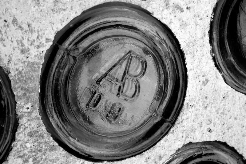
We headed to the bottle house first. It was built in 1906 by Tom Kelly. Rumored to be said there's 30,000 bottles in this structure.


Close up of the bottles used. The "AB" and "A.B.CO" marks are also frequently misunderstood by collectors to mean "Anheuser-Busch", which is definitely incorrect. It's actually American Bottle Company that ran from 1905-1929.

There's old reminisce everywhere you look that people have found laying around from the old town.


Dixie checking out the good smells.


Old truck behind the Mercantile building. I didn't research too much, but with the hood line accent piece it looks to be a 1950's ford flatbed work truck.

After lunch we headed up to the Vegas & Tonopah Depot. It was erected in June of 1909. It was one of the three railroads that served Rhyolite. I found it a shame that a fence needed to be put around it. I can't believe people come out all this way and vandalize places like this. Either that or they don't want a law suit if someone gets hurt.

The big "R" in the ground out front of the old Depot. Back then a nice piece and now over grown and going to waste in the desert.

Derailed old railroad caboose behind the depot rotting its life away. Just imagine what it saw in its life going through the desert back in the early 1900's.

Old structures in the distance.

History everywhere you look. Rockefellers, Standard Oil Company stamp in a drum we found. Started in 1870, became one of the largest corporations in America, took a ton of small business men out and was broken up by the US Supreme Court in 1911. That's a whole story in itself.

It was time to head down to the Cook Bank Building, or whats left of it. The building was erected in 1908. The cost to build it was $90,000.

It featured three stories and a basement. The basement housed the Post Office, the main floor was the bank and business offices on the second and third floors.

For its day it was hi-tech. It featured electric lights, steam heating and marble floors.

It's a photographers paradise in Rhyolite.

The Porter Brothers store ruins. Erected in 1906. They actually had three stores. They moved merchandise from their Ballarat, California store, across Death Valley to their Ryholite "Emporium".

The Rhyolite School ruins. Erected in 1909. This was the second school built in the town and by the time it was complete, most of the students had left Ryholite.

We had a schedule to keep so it was time to leave Rhyolite and head on our way. For more info on this ghost town visit http://en.wikipedia.org/wiki/Rhyolite,_Nevada
Our next quick stop was the Goldwell Open Air Museum where they're phrase is "Art Where it Seemingly Shouldn't Be" And that's the case for sure. Definitely some interesting stuff to see.
CHARLES ALBERT SZUKALSKI
Known for many years in Europe as the sculptor of “ghosts” and a “situation maker,” Albert Szukalski came to the Nevada desert in 1984 to create what is perhaps the most unique piece of his career. Originally designed to endure a mere two years, “The Last Supper” sculpture has not only stood the test of time, but has lived on to become the “genesis” piece of the Goldwell Open Air Museum.

Albert was attracted to the Mojave Desert for many reasons, not the least of which was the Mojave’s resemblance to the deserts of the Middle East. To construct a modern day representation of Christ’s Last Supper, especially so close to Death Valley (where he originally wanted it sited), is eerily appropriate. Working essentially from Leonardo Da Vinci’s fresco of the Last Supper within the desert environment, Szukalski succeeded in blending the two disparate elements into a unified whole. Maintaining the staging of the figures in Leonardo’s work and placing it in the American Southwest allowed the artist to meld Western Artistic tradition with the vast landscape of the New World. Albert Szukalski followed up “The Last Supper” with two other pieces at the site, “Ghost Rider” in 1984 and “Desert Flower” in 1989. [Source http://goldwellmuseum.org/]

DRE PEETERS
“Lady Desert: The Venus of Nevada” becomes then an example of a modern sculpture that helps us re-experience and re-interpret a subject firmly rooted in the Western Fine Art tradition. The human figure, especially the female, is as fresh today in Dr. Hugo’s sculpture, with its computer generated beginning, as it was millennia ago in Greece.[Source http://goldwellmuseum.org/]

FRED BERVOETS
Among the artists that have contributed work to the museum, probably the one who felt most out of place in the desert was Belgian artist Fred Bervoets, appointed a Knight of the Order of Leopold II by the King in 1988. His “portrait” sculpture of Shorty Harris (an early miner in Death Valley and its environs) and a penguin has elicited countless questions. The miner makes sense, but why the Antarctic bird? Word has it that Bervoets wanted to include in his sculpture an indication of how “alien” he felt in the Nevada desert. The penguin was the most out of place entity the artist could think of to represent his own feelings of displacement under the Mojave sun, a self-portrait then as a penguin in the desert. [Source http://goldwellmuseum.org/]

Nothing like taking a break on a huge couch in the middle of no where. I just needed a big remote and a flat screen.

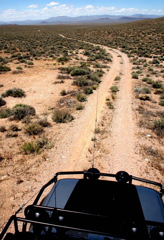
Well enough goofing off and sightseeing. It was time to air down and hit the trail to Tonopah. It's approx 130 miles via dirt and some of it would prove to take a bit longer than anticipated. Weather would change as well. This route is part of the Nevada South-North and follows stage couch routes, freight routes, abandoned railroads and mine roads.
Dixie was ready to rumble. Always on the lookout for Lizards, Cows, anything that might pop out on the trail.

After airing down we quickly hit the only section of the Overland route that passes through Death Valley.

Some of the trail hadn't looked used in a 1/4 century. It was spectacular. We were running solely on waypoints/tracks on the GPS. Some roads didn't even exist on our Lowrance Baja. This is what we live for.

Entering into Sarcobatus Flat. This photo does not do the landscape justice. It looks like we were crossing the world in one shot.


The trail was endless and the wide range of the valley was jaw dropping. It would take us hours to travel this section of trail.

Putting the Landcruiser through its paces. On this trip i was testing some Fox Racing Shox.

The rest of the group behind us as we progressed through the valley.

Approaching Bonnie Claire NV. This Ghost Town was established in October 1906 as a milling center for several nearby mines. Associated with this town was Scotty as many of you know Scotty's Castle in Death Valley. He used this as his construction drop off for the railroad for the castle in DV well known today. Soon after the arrival of the Las Vegas and Tonopah Railroad, Bonnie Clare reached its peak. Mining activity continued until the railroad folded in 1928 and life quickly bailed out of Bonnie Clare. There was some minor activity during the period from 1940 to 1954 but Bonnie Clare has been abandoned ever since. This is the only photo we took of this location as we were pressed for time getting to night two camp.

As we were coming up through towards the Hardluck castle we spotted what look to be a Pronghorn grazing in the wash. As we slowed to drive by slowly and shoot some photos he looked and started walking. We snapped our photo and proceeded to accelerate. Well, he wanted no part of losing to a 8,000 lbs Landcruiser pulling a Teardrop. He started taking off like a bullet.

At first i let off and i didn't want to scare the animal, nor did i want him to hurt himself. But then i realized it didn't matter. We were much too slow for this guy. With my foot to the floor (driving uphill) he pulled away from us like a bat out of hell. He eventually crossed in front of us, then over to the opposite side of the road. It was incredible and something i will never forget.

The Hardluck Castle. Interesting place in the middle of no where. If we had more time, we should of taken a tour. For more info visit their website at http://www.hardluckminecastle.com

We climbed up to 7,000+ feet and crested into the Yucca Valley Mtn Range. It was time to make camp for the night.

Dinner is never shabby, as one person said on this trip... "You'll never starve with the "DUO". We put a small potluck together and it was more food than we thought.

I stayed up and talked to the fire. Im a sucker for staying up later than i should alone in the desert. Just something about the silence of it all.

That night we listened on the ham radios to the NOAA weather report and it said there would be 50-60mph winds throughout the night, clouds and possible snow above 5,000 feet. I didn't believe it.
The next morning we woke up to this. What's funny, is in the teardrop we didn't know anything happened until we opened the door. Hard sided camping trailer for the win!

Just a small amount of snow goes a long way for photography. It makes everything so dramatic and beautiful. This was no exception.


Dixie had a blast running around like a knucklehead.

Yosh with two cups of hot cocoa. Anything to stay warm right?

I don't think the solar panel was doing any good this particular morning.

Part of our group enjoying a nice warm fire in the morning. The cold really brings the family together.

Once again it was that time to get moving. Heading down the mtn into the desert floor again.

Our next stop was Gold Point. Another Ghost Town.

Need a haircut?

Main Street in Gold Point NV


Gold Point is a living Ghost Town that got started around 1902 when Silver was discovered in the area. There's people that run it and about 7 that live there fulltime. During Memorial weekend there's a chili cook off, when passing through we noticed a large number of people in the area. The town is a reminder of the old days and how things can change quickly. When World War II began, the government ordered all gold mines to shut down as nonessential to the war effort. Mining at Gold Point stopped, and once again most of its residents drifted away or went off to war. Then later in the 1960's the mining continued but there was a cave-in in a shaft that was considered not worth fixing to get the mine back up and running. Today there's about fifty building standing and a museum.


Interesting article hung on the walls outside buildings.

Crossing the valley after Gold Point was vast.

Passing near the Clayton Sand Dunes.

The weather was wild on this trip. We saw Hot, Cold, Snow, Sleet, Hail, Rain, Wind Storm, Sand Storm, and everything inbetween. Here's a video clip of the Clayton Valley heading towards Silver Peak.
In this shot you can see the rain storm with the sand storm in the same frame.

Took a lunch break in Silver Peak, not a whole lot to see. Discovered in 1863 makes Silver Peak one of the oldest mining areas in Nevada. Substantial amounts of silver, gold and other minerals have been produced from the area. In 1864 the town of Silver Peak as established because of the springs that are in the area. A 10-stamp mill was built in 1865 and a 20-stamp mill was built in 1867. Mining was far from steady in the area as the mines changed ownership and new milling techniques were invented. The unsteady nature of the mining industry in the area resulted in a huge fluctuation in the population. In 1948 a fire destroyed the town of Silver Peak, and little activity took place in the area until 1966, when Foote Mineral Company started its lithium extracting operation in nearby Clayton Valley.
Now Silver Peak is home to Chemetall Foote Corporation’s lithium mine and mill. This is the only lithium producing mine in the United States. [ Source: Tim France ]

After lunch we drove right on the edge of the sand storm. at the same time we were pelted with hail. I've never seen anything like it.

Heading north through Weepah area we had to bring the trailers down a small canyon. The So-Cal Teardrop "Buzz-Off" and "Krawler 459" had no problems whatsoever. After all, this is what they're built for.


Making the final push of the 130 miles offroad into Tonopah. The roads were smoother than some here in Los Angeles!

We had made it to Tonopah. We aired up, fueled up and grabbed some supplies. It was very cold and windy.

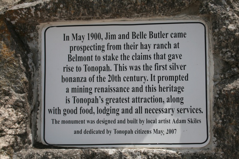
Funny story on how Tonopah came about. The community began about 1900 with the discovery of gold and silver rich ore by prospector Jim Butler when he went looking for a lost burro (donkey) he owned. The burro had wandered off during the night and had sought shelter near a rock outcropping. When Butler discovered the animal the next morning, he picked up a rock to throw at the beast, but instead noticed the rock was unusually heavy. He had stumbled upon the second-richest silver strike in Nevada history. The ore eventually played out, and abandoned mines can be found throughout the area. [Source - Wikipedia]

After hitting the pavement east we ran into some more snow flurries and my wipers didn't function. That's always a fun time no matter how you slice it.

Our next stop was the Lunar Crater sixty miles east of Tononpah and about nine miles south off highway.
Our camp on the edge of the crater. You don't notice how massive the crater is, until you look at our camp as a dot on the photo. We didn't see another sole in sight. Just the way we like it.

Zoomed in with the 300mm lens and double.

Campfire that night was a chilly one. The storm was just passing and as many know is the coldest time because the clouds don't hold any heat in. Sure made for a breath taking backdrop.

The next morning i took a hike up and carried my trip pod and long lens up to the nearby plateau for a view of camp. Spectacular and very worth the effort.

Monday was Memorial Day so we only felt it was necessary to show our pride. This also has rumored to be an area where Astronaut testing/practice was accomplished for moon walking.

The last day of the trip had come and we had a long haul to get back to So-Cal in one shot. That and the Memorial day traffic would be meeting us halfway in Vegas so we could crawl home. In other words, we had to keep the sense of urgency and get moving.
We made one more off road loop to the highway that didn't take up too much time and had some beautiful views. We all wish we could of stayed longer.
 4
4Dixie enjoy every minute as always. Good smells after the fresh rain storm.

The gang coming along nicely. Nobody had any problems whatsoever which is always a good thing on a Overland trip like this.

We tried to drive the old highway as far as we could. Didn't last very long.

The entire Basin is an open range, so you need to keep an eye out for any wildlife that may walk into the road you're traveling. This happened to us numerous times. Seemed like each time i was looking down at the GPS too.

I thought for a minute this guy was going to charge my driver side door.

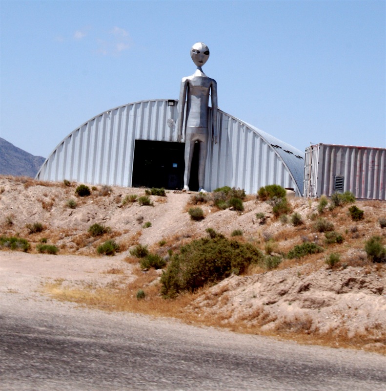
We took the Extraterrestrial Hwy south east towards Vegas. It was interesting to say the least. We saw a dead cow, maybe it was just abducted?

There wasn't much in the way of stops for lunch, so we stopped at a gravel pit. It ended up working out pretty well.

The kids have a great time sliding and playing on the gravel piles after lunch.

Even i slid down on my butt. Anything for a shot right?

The adults tried to contact Aliens on the radios, a must when you're that close to Area 51. I think we picked up a fighter jet.

I want to thank the Gabe from SoCal Teardrops, his family and Travis from Safari Pacific for joining us on this adventure. You guys made the trip all that much more better. I want to thank Kristian Saile for recommending the Lunar Crater as a place to camp. It was epic and we appreciate it. Lastly, i want to thank Tim France for putting this Overland Route up on the portal routes page. Thank you for all the hard work of assembling it. The entire route from Orange County CA and back was 1,065 miles. For more info on this route head to http://www.expeditionportal.com/overlandroutes/index.php?title=Rhyolite_to_Tonopah
Quick Note:
Services are only available in Beatty and Tonopah. When traveling this route carry everything you need. This is a very remote area and should not be taken lightly. Cell service and ham repeaters are spotty at best. Most of all, good common sense is a must. A minor problem along this route can easily be catastrophic.