Deep in my head for a couple years now has been an idea to take a handful of South West Overland routes and wagon roads and connect them all together to make a trek across from Southern Arizona near the Mexican border to the California sands on the Pacific Ocean.
As more of a day dream more than anything, this envision became clearer and more precise as months went by and maps were hung, routes were sketched and pre-run trips were planned. This trip would take a good amount of planning. We didn't know what some portions would have in store until the day of arrival. We also didn't know for sure if there would be locked gates, over passes we couldn't fit under or barriers in our way. The goal was to make the trip as much as possible on dirt and without using much assistance for supplies as possible. We'd carry large aux tanks of fuel and water. We'd run dual freezer fridges, and figure out the rest on the way.
Assembling maps back in May 2010.


The route would utilize some well known overland routes that many still travel today. El Camino Del Diablo, Bradshaw Trail, Mojave Road and others made up the staples that held the trek together. The mileage would be 1,000 one way with about 857 of it off pavement. A couple sections would take 10-12 hours to traverse and one section be it 400-500 miles off pavement before any petrol station in sight.

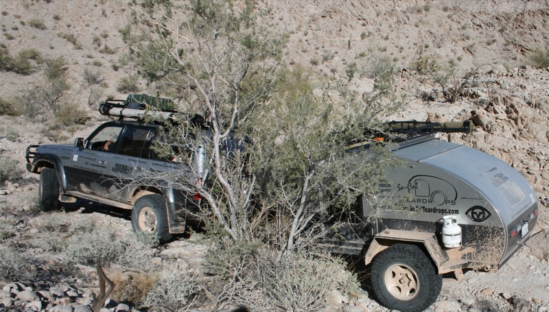
In preparation for the trip the truck and trailer were gone through more than what we'd normally do before a trip. From AJIK Overland Exchange the truck received full hose/coolant replacements as well as seals from our boys at Yotamasters that were leaking or looking like they may give up the ghost along the way. All tires were replaced right before we departed with the tough going E load Cooper Discoverer S/TMAXX and all drive-train was inspected, tightened and lubed.
Because i've led other runs in the past and large groups, i know whats best for a long expedition trip where you're running a large number of miles per day and camping somewhere new each night. You really only want a few rigs, two is ideal. The problem with large groups is it takes too much time to move from place to place and there are too many other agendas and factors like "potty breaks" setting in. Before heading out we discussed the time window needed and operating costs with a couple close friends, but none worked out to their exact specifications. Time was closing its grip and we wanted to leave within 2011 time frame. Upon the list of on deck adventurers was a very special couple, Verny and Itzia from Baja Overland.

Long time back country travelers with history in backpacking and overlanding they were right at home with heading out into the great unknown. They also drive an 80 series Landcruiser, and packaged with an African overland trailer with a really cool chocolate lab named Chili they were a shoe-in. Both trucks were almost identical in setups as well, which made it nice in case of spare part swapping, critical needs and towing capability.

After pre-running a couple legs, getting camera and video gear together, it was time to hit the road to Ajo, Arizona for staging. Ajo would be our departure location as it was the last fuel and supply stop on the route before entering the desolate Sonoran desert. Call us Glampers, but we chose to take advantage of the nice accommodations and rent cabins the night before. This would prove a great way to settle in after a bit of a drive from California.
Waking up early and excited to get started, we anxiously headed for the trail head to air down and get ready to head west for the Pacific. The original plan was to head north from the Mexican/Arizona border via Puerto Blanco road, but at no surprise it was closed due to illegal activity. This would mean we'd get our start immediately out of town on the "Highway of the Devil" just south of Ajo and about 50 miles from the border.

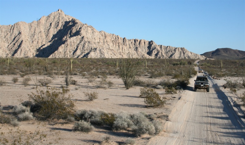
El Camino Del Diablo as it is referred to mostly is a long stretch overland route that spans from Ajo Arizona to Yuma. Reported by many to be one of the most remote places in the United States, this historic route shortcut linked spanish settlements in Mexico to what is now California during the frontier days. It once was a 250 mile route that started down in the Sonoyta area and reached far northwest as Yuma. Many made their way west in search of the Colorado river. History shows us that even as early back as 1540 Captain Melchior Diaz led a expedition through this area in search of a route to the Pacific. El Camino was shorter, cheaper and safer than sailing around the tip of Baja. The route was directed through major water holes for slight chance of survival. Along the trail there are numerous amounts of grave sites as a grim reminder.

At many points during the trail you'll come very close to the border. At one point i think the GPS showed us as close as 3/4 of a mile. With this in mind, it's not uncommon to run into the occasional Border Patrol vehicle. They will ask you where you are headed and where you are from. They may even ask for your permit for the Barry Goldwater Bombing Range.
Remember, where you can't see them - They can see you.

Passing by one of the many outposts in the area.

Many sections of El Camino are very sandy and silty. There can sometimes be 2 foot deep ruts that you travel aggressively as to not get stuck. Well, this time of year (Winter) there's more mud and rain than anything else and it played a little havoc getting through some heavily rutted areas. Locked and loaded with momentum being your friend we made it through unscathed. The new Coopers did amazingly and they threw the mud out afterwards quickly so they could provide traction the rest of the way.

An interesting site on the route are these help signs that have been established along the way in various locations. Apparently you push the button, whether legal or illegal and the authorities will come save you and eventually return you to safety or deport you. Wild. The tires behind the sign are rounded up together to drag behind vehicles to smooth out sections of road so that the BP can track footprints in the sand. The mirror dangling from the signage is so people in need can recognize the location from a far.

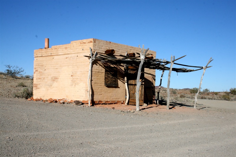
A casita built by the Luke Air Force Base Civil Engineering Dept located at Tule Wells.
Dixie always ready to go.

Heading from the Christmas pass section near Tule Wells over to where we'll make camp for the night. The Tinajas Altas mountain range very far in the distance.

In order to complete this trek in the amount of time we had away from our business we had to hustle some days more than others. Some of it was a shame and looking back i kind of regret it, but there was nothing much we could do about it. Just the way it goes. On this day, we had to run 80% of the El Camino Del Diablo section to get the Yuma on schedule and head up to our next leg.
Camp near Tinaja Atlas tanks was a beautiful one. There are several perched watering holes that step up the side of the rock range that serve as another stop for many in need of water. In certain times of the year they'll hold 20,000 gallons of water combined.

A man and his BBQ... yes even in the middle of no where.

A nice first night around the campfire with friends. A few folks from other parts of the country jumped in on this first leg and we were happy to have them.

The next morning we made breakfast and headed west. The next section over the pass to Yuma would prove to be slow going and take hours to traverse. It would also prove to be one of the tightest and rockiest sections of our journey.

There were tight spots for the trailers as we rounded gullies and ledges. As long as we kept a keen eye we were fine. Nothing a little wax couldn't buff out when we got back to civilization.


Coming down the backside of the pass on the west.

Nearing Yuma, we started getting into laser field practice areas. Not uncommon as part of practice, the warning signs are legit. Sitting around a campfire on this exact trip we saw lasers in the sky buzzing miles away from our camp. It's also not uncommon to see a helicopter land and ask you for identification and again to ask, where are you from and where are you headed.

Passing through Yuma and into Winterhaven we headed northwest to Picacho SRA. It's about 24 miles north of Yuma in the dirt off the beaten path. Picacho is an old mining town that at one point housed over 100 residents. There's not much left, but there's hiking, fishing and wildlife viewing. This park is on the list for California closures so we need to work hard to keep it open. It's a shame to see something so beautiful get shut down.
Once in the park, we continue northwest along shelf roads that run next to the Colorado River. Not a place you want to be in a large storm. Many of the trails/roads can become impassable for a lengthy amount of time. It's truly breath-taking. Still one of my favorite places to visit.

A friend of ours from Canada tooling down the trail for a few legs of the Expedition. He was happy to get out of the freezing cold up north and come down to the sunny southwest.

The grave of "Lonesome" up on top of Bear Canyon at Picacho Point. A dog that was buried by his master in the 1980's. There is guestbook to sign and if you feel inspired or moved you can place a stone to add to the hill.

Arriving at the Colorado. A change of pace of the last couple hundred miles of pure dirt. Although freezing water run off from the Rockies, it still looked somewhat inviting after being on the dusty trail. By the way, this also meant we were in California now.

Looking northerly. California on the left handside of the photo and Arizona on the right handside. The river divides the states.

Arriving at camp this is what we pulled up to. Yosh and I had already been to this location in the past and knew what to expect and appreciate. However, it was great to see everyone elses jaws drop when they stepped out onto our own private beach camp on the river that looked like glass.

Off loading the days photos and video content to make room for the next day. Mobile is the name of the game on a trip like this. Portable hard drives are your friend.

At the end of the day, it was Christmas Eve. So we went all out knowing we were in a park where we had proper tables to utilize and some of our friends were going to head home early. Everyone pitched in as we created a potluck like no other. It was spectacular and quite the feast! We even brought a small Christmas tree.

The next morning we hit the trail again. This time we'd be heading due West through a Gavilan Wash and then out Indian Pass towards the Imperial sand dunes. Although some sections have deep sand and tight canyon walls, if you keep your head about yourself and constant steady throttle you can prevail without problems.

Indian Pass and the trucks making their way through. Not the hardest section of road we've ever driven, but it would be a challenge in a stock height SUV. Ground clearance is somewhat critical as you climb out of the wash. It's not uncommon to see wild horses burros down in this area.

Arriving on top of the desert floor after climbing out of the canyon below. Jagged mountain ranges line up the back drop in the Chocolate mountain range. The road smooths out from here and is lined with lava type rock fields. Also the wind tends to be heavy once on top of the plateau.

Make sure to check back for Part 2 of our CalZona Expedition Series. Where we run from Picacho up to Wileys Well, then hit Bradshaw Trail to Red Canyon Jeep Trail and north to Joshua Tree and into the Old Dale Mining District. We run into a problem or two, see some interesting things, say goodbye to a couple of explorers and have a great adventure!
Also look for a narrative DVD of the Expedition coming in Late Spring 2012.