
Upon completion of Indian Pass and before hitting any pavement whatsoever, we made a hard right and headed North on an old power line road. See, In the desert when you can't find your way you can many times look to powerlines to guide you. They usually contain access roads that will let you cross huge scale portions of the desert in a timely manor. We'd continue this northernly pattern near highway 78 till we passed a Border Patrol check point out of site of the agents and finally head North West through Milpitas Canyon. It was a long few hours of winding slow pace moving because the towers ran between many rolling sand hills. In some sections the service road disappeared to where we had to find the road again. The good thing about the slow pace was that we had time to make a call to our families on Christmas day as for some reason we had cell reception on one of the carriers. The families at home were happy to hear from us, as this was the first time we spoke to home since we left days before.
Our goal after lunch was to head north far enough to where we'd tie into the Bradshaw Overland Route, an old wagon road that runs from today's Ehrenburg to the Salton Sea. Once at the old overland route, we'd reach a somewhat primitive campground called Wiley's Well.

Wileys Well campground name comes from a well that was dug deeper by A.P. Wiley in 1876. He was hoping that providing water and having a deep well would attract people from the Bradshaw stagecoach route to his general store. Today snowbirds from colder areas of the USA visit the area and it's home to rock hounds that collect geodes. Another site to see are the tank tracks still left today from Patton's men desert training for Africa back in 1942.


After a rest for the night, it was time to say goodbye to our good friends that joined us for part of the journey. Big thanks to Mike and Colin for spending time with us on the trail. The rest of the trip you were missed. We well wished travels and headed Westward towards the Pacific.

A few miles down the road we ran into this boat hull mold. Almost like Noahs Arch. This hull mold wasn't there last time i ran through this area. Definitely new since 2009-2010.

The Bradshaw Overland Route frequently comes in contact with the Chuckwalla Bombing Range throughout its extent. At any given point, you'll see fragments and pieces that remind you of that. This section was no exception.


It helps to keep your eyes peeled at all times when in the desert. You may miss a historical site at any time. Here we see what's left of an old Stagecoach stop from late 1800's.

Crossing the Eagle Mountain Rail Road line. No longer in use. The Eagle Mtn RR was owned and operated by Kaiser Steel back in the 40's and 50's and all the way until the last train passed in 1986. They transported iron-ore from their mine to to their plant in Fontana.


As we entered into Salt Creek Wash heading West towards the Salton Sea we broke off Bradshaw and headed North on Red Canyon Jeep trail.

The trail isn't too difficult, but with blind up hill ridge corners it made for a nerve racking experience. Combined with never driving it before, we didn't really know what to expect. Locked and loaded and a little tight in certain sections we had zero problems to speak of.

The view out your drivers window at the Red Canyon wash down below. Spectacular!

After finishing up Red Canyon and taking much longer than anticipated we arrived at Chiriaco Summit for fuel and supplies. The next leg would be 400-500 miles off highway without so much as a drop of fuel. At this point we filled our fuel cans and aux tanks. We also checked the trucks for anything that could rattle loose and made a visual inspection. At this point, we noticed our multi-axis coupler had come loose and was about to separate. This wasn't good. The roll pin that holds the two pieces together in the design was dislodging. We tried using a brass hammer and taping the roll pin back in it's home, but it was not working. This was going to be the end of the trip if we had to ditch the trailer.
Here's a shot of the coupler before we left. It's a Max Coupler. You can see the roll pin above the zerk fitting in the bottom of the photo. The pressure is so high they push right out.

After a bit of digging Verny and Itzia sourced a spare Lock N Roll coupler that had a hitch already on it and it was the right length and ready to go. We were extremely lucky because i don't know of anyone that would carry a spare coupler.

After the near miss of having to abort the run and dodging having the trailer being flatbeded home, we headed on our way North through Joshua Tree National Park and into the Old Dale Mining District. The weather was perfect with temperatures in the 70's and the sun behind us. We were thrilled to be able to continue.

Passing the Joshua Tree boundary and climbing up into the Old Dale Mining area. This section was rocky and slow going. We just about ran into the dark and everyone was starting to get fatigued. Soon we'd find a great spot in a saddle of the mountains to protect us.


Camp was a beautiful one for the night. Solitude at it's finest. Not a place you can get a Subaru to that's for sure. On this particular night around the campfire we viewed laser practice from aircraft based at the 29 palms Marine Air Ground Task Force. It was breath-taking and only lasted a short while.

The next morning we relaxed getting going because the day before was so long. Dixie enjoyed a scratch and took a nap.


After packing up from the night before, just beginning to leave camp and head north towards the Mojave Road a leak was spied by Verny under his rig on the steering. It turned out to be a radiator coolant hose clamp that was loose on a brand new hose. We were happy for that since it's a simple fix.

The biggest thing you can do for yourself in a broke down scenario is to keep a great attitude. Don't get upset and angry, it won't get you anywhere. Take a deep breath, walk away for a minute, re-group and figure out a plan to repair. Verny is the epitome of such behavior. He smiled the entire time.

Proceeding through the Old Dale Mining district the rocks became less and less as we headed north. We hit the old highway 62 and headed east to an old power line road. After a good four to six hours off highway this route would link us up with the Mojave Road near Fort Piute just before dark.

You can never expect your planning or a route to be absolutely clear on a trek like this. You just can't. There's too many different variables and too many different problems that can arise in any given number of days.
A prime example in our case, we ran into a problem where we had to cross some railroad tracks but the crossing was torn up and the rails were deep. This wasn't so much a problem, rather than a diversion for us to head around up and over. We found a crossing just to the east.

Once tied into the Mojave Road, we hooked a hard left to head West. From there we continued up the Ft. Piute bypass and up to camp. It was nearing the end of the day and the sun was in our eyes most of the way up. Back in the wagon train days, they just would head straight up and over. We can no longer do that being that it's a Preserve.

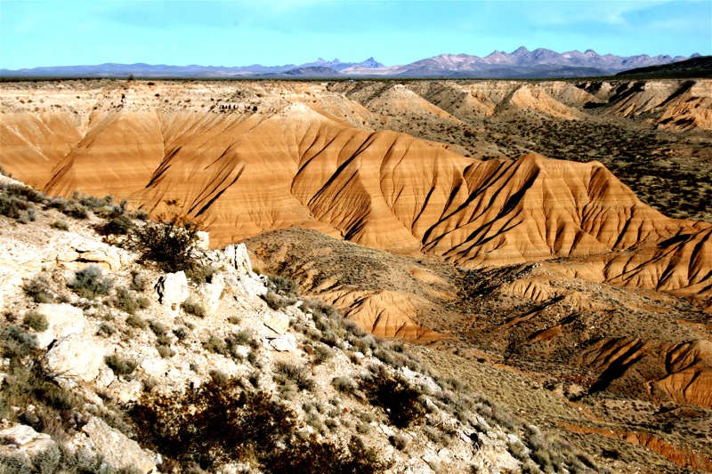
Once up on top of the Lanfair Valley area we headed over to a ridge camp on the Piute Gorge. We'd call this home for the night. It was epic. The lines in the cliffs reminded me of Utah and parts of Arizona.

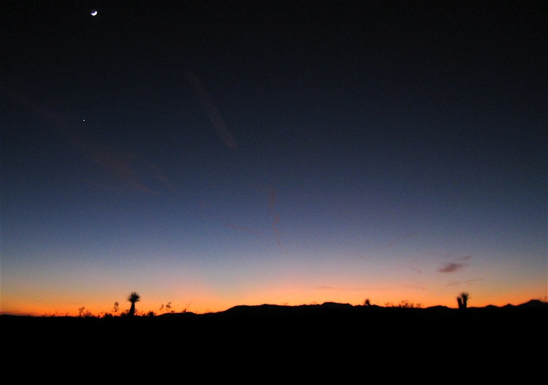
The sun went down as we prepared hot soup on a cold night. Yet again, it was another amazing day with a beautiful desert sunset.
Join us for our final installment to see more history along the Mojave Road, run into interesting road hazards, some very different terrain changes and to see the finale of our adventure as we arrive at the Pacific Ocean.